NEWS27 July 2024
isardSAT, an R&D SME providing Earth observation solutions, has led the development of a new Synthetic Aperture Radar (SAR) processor to monitor coastal changes in the UK and worldwide, regardless of the weather or time of day.
The company, whose UK-based team operates from Surrey Research Park, part of the University of Surrey, is leading the development of a new processor which enables coastal erosion data to be retrieved from SAR data.
With more than 890 million people – around 11% of the world’s population – living near oceans and coastlines vulnerable to climate change, not only because of floods and storms but from erosion and rising sea levels, isardSAT’s new technology will provide valuable insight to inform scientists and policymakers.
In the UK, current projections show climate change is likely to result in a rise in sea level of up to 1.12 metres by the end of the century. However, most of the highly populated coastal cities are in the Southern Hemisphere, where Earth Observation data is often unavailable.
SAR data: observing the coastline through the clouds, anytime
Coastal change has traditionally been monitored using optical sensors and imagery. These, however, can be inaccurate because the waterline is tidal and different heights may be recorded for the same section of the coastline, depending on the time of day. This can hamper the definition of the shoreline.
By contrast, research by isardSAT shows successful results of an SAR shoreline processor to pinpoint the actual shoreline from data gathered from different satellites. Unlike optical sensors, SAR uses an active beam of microwaves to create high-definition imagery anywhere on the globe, regardless of cloud cover, light levels or the time of day.
The processor and related study, developed in collaboration with the Hydraulic Institute of Cantabria, The British Geological Survey, The Maynooth University and the Geological Survey of Ireland, achieves especially good results with flat beaches
Case Study: Bull Island, Country Dublin, Ireland
One example of a flat beach analysed with the isardSAT’s processor is located on Bull Island, in the Irish Sea. Using data gathered between 2016 and 2022, the results confirmed the alarming trend of the coast’s regression, which is receding at 10m per year in some areas, resulting in some areas losing up to 60 metres of surface width to the sea.
“There’s some scepticism in associating coastal monitoring with SAR, favouring optical technology analysis instead”, explains Salvatore Savastano, lead author of the study.
“However, SAR has great potential and allows us to detect surface features that optical sensors cannot capture. We are working to capitalise on the benefits of this technology as much as possible, improving our product even in more complex scenarios, which will expand its applicability”, adds Savastano.
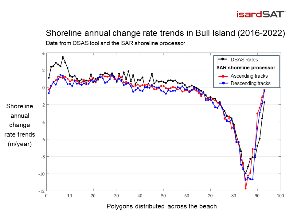
Above: Comparison of shoreline annual change rate trends (m/year) detected by DSAS tool (black) and the SAR processor developed by isardSAT (red and blue). The profile shows very strong agreement in the change rates, both for the processor’s ascending and descending tracks. © isardSAT
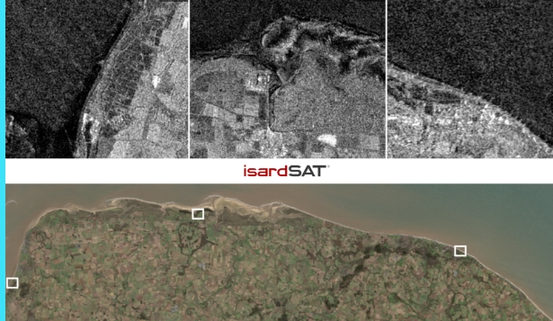
Below: In Salinas beach (Spain), the shoreline was identified by filtering all the shoreline points detected (1 to 2), and creating polygons from the shoreline definition. © isardSAT, Google Earth.
Discover more:
Check out this story to discover more use cases for isardSAT’s new coastline monitoring processor.